Tuesday, February 02, 2010

Viewing Open Street Map on iPhone Off-line

oMaps on iTouch
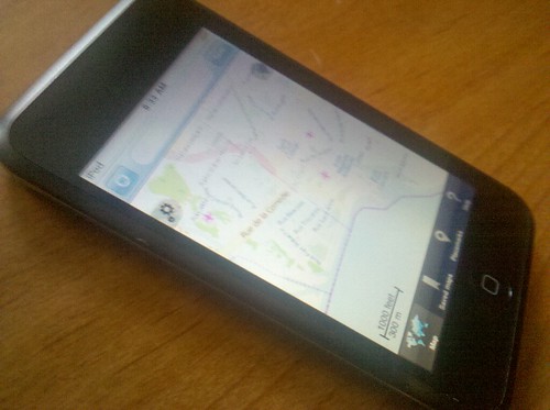
There is a great application call oMaps available in the Apple App Store that allows off-line caching of Open Street Maps. This app is perfect for use by those traveling abroad with prohibitive international data charges. How prohibitive? Well, AT&T is charging $20 per megabyte for rescue and relief teams in Haiti. Classy.

Update 7:05PM GMT - AT&T is waiving international roaming fees for calls, txts & data for customers in Haiti. See att.com/gen/press-room?pid=4800&cdvn=news&newsarticleid=30461. That is classy. Thanks, Meg!

oMaps and Open Street Map to the rescue!

oMaps is available for a mere $2 on the app store, thanks Thomas Bonnin.

Update Feb. 3, 2010 5:54PM GMT - Clarification. This is not sarcasm. This is one amazingly powerful application well worth a modest two bucks. The developer, Thomas Bonnin, when he found out how it was being used in Haiti even offered to comp me some licenses, but in my mind if you make something awesome and charge a fair price you should be remunerated. Now that I know how well it works, I'd willingly pay more.


On first install it caused all my third-party apps to immediately crash on open. I don't use my iTouch much, apparently this is common. Synching my iTouch with iTunes on my computer fixed it as described in this thread discussions.apple.com/thread.jspa?threadID=1850638&st...

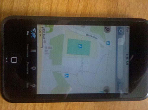
Afterward the application is downloaded and installed, here are the steps to save maps for off-line viewing:
  1. Find your area of interest, you may search but only by major features, e.g. "Haiti"
  2. Zoom out as far as the application will allow you to and still be able to save (button in upper right). I was able to zoom to an extent that included Jacmel in the south and the pass on Route 4 at Bois Cercueil in the northwest. If you need a larger area than this, then you will want to save separate maps.
  3. Press Save and name your map.
  4. Now turn off wifi (and all network connections - if an iPhone put it in airplane mode) and ensure that you are able to zoom in and out of the downloaded map.

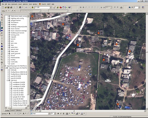
The best part, for Haiti at least, is this the absolute best map available. It is current as of the moment I downloaded it as maintained and updated by the Open Street Maps Community. Includes refugee camps, road blocks and collapsed buildings. Better still, the GPS on an iPhone will work without using data charges to update your location on the map (just make sure the 3G networking is turned off or you'll need a relief effort to pay your mobile bill).

Open Street Maps via oMaps on iTouch

A more thorough review of oMaps is available on The Apple Blog.

Monday, February 01, 2010

Helping Haiti from Home

Haiti - Jacmel - Trou Bourrique

There are many substantive things you can do to help from home beyond sending your dollars and euros.

For map geeks such as myself, one such project has emerged out of the Open Street Map (OSM) Community called WikiProject Haiti. These guys are crowdsourcing the mapping of Haiti with astounding success. Just check out the Tasks and Ideas Page most of which are already completed! Beyond awesome. This isn't mapping for future use, this is mapping for use in the field right now.

Tons of resources here including a catalog of printable and static maps, video directions on uploading OSM data to a Garmin GPS and even how to access OSM data behind the closed doors of ArcGIS.

I have a good friend headed to Jacmel, Haiti in a little over 24 hours to provide logistics and support to a medical team. The work of the OSM Community is an incredible resource to them - the only current maps available.

For the town of Jacmel, OSM just added the following summary and mapping needs:

Mapping: The town of Jacmel in the south has already been mapped in three iterations: first based on an old CIA map, which was completely replaced by two mappings based on satellite imagery from DigitalGlobe. Now, the NOAA aerial imagery collected on 2010-01-24 is available for Jacmel and the current map should be improved and checked in another iteration:
  • there are dozens of unmapped refugee camps, mainly east and north of the center
  • the road network is currently badly aligned. NOAA imagery should be the reference imagery now and the grid should be adjusted to it. Fix the road network and adjust already mapped areas with landuse=residential, natural=xyz, etc.
  • the road network is incomplete because part of the former imagery was covered by clouds and/or distorted. Check the road network, in particular in densely populated areas. Are there any missing residential roads or visible paths/footways?
Progress:
  • Adjusted the center of Jacmel, mapped refugee camps in the center. Gubaer 18:14, 29 January 2010 (UTC)
I'm going to see what I can do to help with their effort as soon as I finish producing maps for the team prior to their departure.


View Larger Map

Fellow GeoGeeks, I'll keep you posted on what you can do to assist.

Update Feb. 2, 2010 3:48AM GMT - For those looking for some background for getting into OSM, here's a Beginner's Guide