
There are many substantive things you can do to help from home beyond sending your dollars and euros.
For map geeks such as myself, one such project has emerged out of the Open Street Map (OSM) Community called WikiProject Haiti. These guys are crowdsourcing the mapping of Haiti with astounding success. Just check out the Tasks and Ideas Page most of which are already completed! Beyond awesome. This isn't mapping for future use, this is mapping for use in the field right now.
Tons of resources here including a catalog of printable and static maps, video directions on uploading OSM data to a Garmin GPS and even how to access OSM data behind the closed doors of ArcGIS.
I have a good friend headed to Jacmel, Haiti in a little over 24 hours to provide logistics and support to a medical team. The work of the OSM Community is an incredible resource to them - the only current maps available.
For the town of Jacmel, OSM just added the following summary and mapping needs:
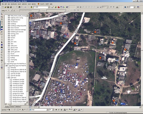
Mapping: The town of Jacmel in the south has already been mapped in three iterations: first based on an old CIA map, which was completely replaced by two mappings based on satellite imagery from DigitalGlobe. Now, the NOAA aerial imagery collected on 2010-01-24 is available for Jacmel and the current map should be improved and checked in another iteration:I'm going to see what I can do to help with their effort as soon as I finish producing maps for the team prior to their departure.
Progress:
- there are dozens of unmapped refugee camps, mainly east and north of the center
- the road network is currently badly aligned. NOAA imagery should be the reference imagery now and the grid should be adjusted to it. Fix the road network and adjust already mapped areas with landuse=residential, natural=xyz, etc.
- the road network is incomplete because part of the former imagery was covered by clouds and/or distorted. Check the road network, in particular in densely populated areas. Are there any missing residential roads or visible paths/footways?
- Adjusted the center of Jacmel, mapped refugee camps in the center. Gubaer 18:14, 29 January 2010 (UTC)
View Larger Map
Fellow GeoGeeks, I'll keep you posted on what you can do to assist.
Update Feb. 2, 2010 3:48AM GMT - For those looking for some background for getting into OSM, here's a Beginner's Guide

3 comments:
Could you direct me to where I could download high resolution aerial imagery of the Jacmel region? I noticed a screenshot of an ArcGIS setup with Jacmel aerials (Pinchinat, soccer field camp)
I am part of an incorporated group of non-profits out of New Orleans coordinating delivery of recovery resources to the region. A GIS-ready geo-referenced tiff would be ideal, as I'll be operating without the luxury of google maps/google earth access while down there.
I appreciate any help or direction you can provide.
Thanks,
Ritchie
rkatko@makeitrightnola.org
All publicly available imagery with extents may be found @
http://wiki.openstreetmap.org/wiki/WikiProject_Haiti/Imagery_and_data_sources
You may also what to check out the awesome iPhone/iTouch app oMaps that our team used successfully in Jacmel. Directions on using oMaps. I believe there is also a version for Android.
Sorry, here's the link for oMaps directions:
http://blog.stupiddingo.com/2010/02/viewing-open-street-map-on-iphone-off.html
Post a Comment